Summary
The search for mineral resources in the crystalline crust has become increasingly challenging as the need to explore deeper becomes an economic reality. Canadian mining camps continue to deplete their historical reserve base from decades old surface discoveries or deepening mine extensions. Ongoing efforts are focused toward developing technologies capable of identifying new, deep, reliable drill targets. In order to be economically feasible in these times of persistent low commodity pricing, exploration for these deeper targets must be conducted relatively close to existing infrastructure investments. Consequently, new technology initiatives have an opportunity to build upon decades of geoscience efforts already undertaken; however, excluding deep drill information typically concentrated in the near vicinity of existing mines, knowledge of this deeper stratigraphy continues to be poorly understood.
To augment Noranda’s deep search initiatives, the company has modified and implemented existing seismic technology to detect and target massive sulphides located at depths ranging from 500 – 2000 meters. In the fall of 1998 and early 1999, Noranda completed an 18 km2, three-dimensional (3D) seismic program in central New Brunswick by successfully drill testing an impedance anomaly and locating massive sulphides at depths in excess of 1100 meters. Follow-up modelling provided value added information on size and tonnage, which was used to develop the most cost-effective and timely drill assessment of the resource.
Introduction
Seismic reflection technology has been deployed for over 75 years in the Petroleum Industry and over that time has evolved as the primary exploration drill-targeting tool. With the exception of Noranda and Anglo (Campbell et al., 1984; Campbell, 1990; Durrheim et al., 1991; Pretorious et al., 1997), there have been few significant ongoing seismic programs in the hard rock Mineral Industry. In order to augment their deep search challenges in mature mining camps, Noranda embarked on an aggressive initiative in the early 1990’s to try to establish whether seismic data could adequately and cost-effectively screen deep stratigraphy (500 – 2000 meters) by providing reliable and accurate targeting of potential new massive sulphides.
Lithoprobe, while primarily designed to investigate the large-scale structural makeup of the craton, had already established that seismic data could identify interesting, relatively shallow reflection events. Template 2D studies over previously identified massive sulphide mineralization (Milkereit et al., 1992, Milkereit et al., 1996, Calvert et al., 1999) had provided some encouraging indications of seismic data’s potential; however, the images were complex and open to varying interpretations. Given the typically complex nature of the Archean crust, it was apparent that a 3D survey would be required in order to clearly demonstrate the reliable and cost-effective usefulness of seismic data as a deep search tool. As part of this demonstration, detection and drill testing of a new, undiscovered massive sulphide of potential economic scale would be required in order to finally validate the technique. Identifying a new zone of mineralization was yet to be documented.
The Challenges
When compared to the Petroleum Industry, there are a number of issues that make seismic surveying in hard rock terrains both difficult and challenging. Some of these include:
- The Signal:Noise (S/N) ratio is generally significantly lower than that typically experienced in oil and gas exploration. Questions remained concerning instrumentation and recording parameters that could provide the required data quality.
- The near surface weathering statics are severe and adequate geophone coupling is always demanding.
- Overall, the Mineral Industry lacked the necessary physical property databases to make informed decisions about what might or might not be possible in a particular exploration area.
- Given the typically intricate nature of the geology and recorded responses, stronger interpretation tools for 3D data integration and modelling were required.
- The recorded wavefield is complex and massive sulphide targets potentially manifest themselves as secondary scattering sources (Eaton, 1999).
- Could a cost-effective methodology be developed to effectively screen prospective geology at depths of 500 – 2000 meters?
The Seismic Program
The seismic program at Noranda began in earnest in 1995 when a 2D line was recorded in the Matagami mining camp. The 2D line was used to establish the field parameters that would be required to conduct a subsequent 3D template seismic survey over the existing, and yet unmined, Bell Allard massive sulphide deposit. The survey was acquired in the late winter of 1996 and covered approximately 20 km2. While the massive sulphide was detected in the final 3D volume, the hosting stratigraphy is complex and produced significant reflectivity (Adam et al., 1996). Results from this work were encouraging. Many of the technical challenges appeared to be solvable; however, the complex seismic signatures left lingering doubts as to the overall cost-effectiveness of using seismic data as a deep targeting tool. The problem was how best to integrate all the various types of geophysical and geological information available into one unified earth model. This would provide a better understanding of the seismic wavefield and help resolve the uncertainties and lingering skepticism in management’s mind. What was required was a software system capable of integrating and visualizing in three dimensions cultural, seismic, potential field, electrical, geological and borehole data. A detailed evaluation was undertaken to identify the best software solution available. GoCad was chosen as the most appropriate earth modelling system because of its advanced surface, volume and 3D visualization capabilities. Additionally, the software was capable of easily integrating all the various spatial data types mentioned above. From this integration emerged a better understanding of the seismic response and clearly demonstrated the need and significant leverage to be gained by constructing data-consistent, 3D earth models of this type. Noranda adopted this data integration methodology for both interpretation and presentation when dealing with the very complex three-dimensional geology and geophysical datasets common to the crystalline crust.
Noranda’s seismic program advanced on parallel paths with physical property measurements being gathered and analyzed at a variety of other sites of exploration interest. These data would be critical to effectively and successfully model, evaluate and subsequently implement seismic programs where the potential for success seemed most realistic. Average velocity and density limits had been reported in the literature for some volcanic rocks as early as the 1960’s (Parasnis, 1966). Historically, however, the Mining Industry had put very little effort into gathering this type of information as it was deemed to be of little value. Primarily through the efforts of the GSC, the tools and techniques to routinely gather high quality rock property data from both core sample and continuous borehole logging (Salisbury et al., 1996, Killeen et al., 1995) were developed.
As the understanding of the technical and site-specific issues evolved, a protocol was established and routinely implemented for the successful implementation of seismic techniques. This methodology consists of the steps: (a) core rock property measurements, (b) borehole logging, (c) forward structural and stratigraphic modelling, (d) 2D field parameter testing/templating and finally (e) 3D survey acquisition and interpretation for drill targeting and/or area screening. Each is conducted in a logical sequence, as each carries information vital to the success of the next. Additionally, the process evolves from the least costly data gathering and analysis procedures to the most costly and can be terminated after any step should the conclusions not encourage further work.
Halfmile Lake, New Brunswick
Halfmile Lake is located in the highlands of central New Brunswick. Lead-Zinc sulphide mineralization was first discovered here in 1954. Over the course of the next 40 years various companies held the claims and continued to do geophysics and drilling in an attempt to increase the established reserves to the point where mining could be considered.
The iron-rich massive sulphides are contained in an extensive mineralized sheet totaling over 25 million tons (MT) in size. The deposit is hosted by a typical volcanogenic massive sulphide (VMS) sequence of felsic volcanics, metasediments and intermediate volcanic rocks of Cambro-Ordovician age. All have been metamorphosed to greenschist facies (Adair, 1992). There have been four documented phases of fold deformation and accompanying faulting in the area. Figure 1 shows a geologic cross section of the deposit. The sulphides are within an overturned, large antiform, which dips at a moderate 45° - 60° to the NNW; however, local structural influences can steepen dips to near vertical.
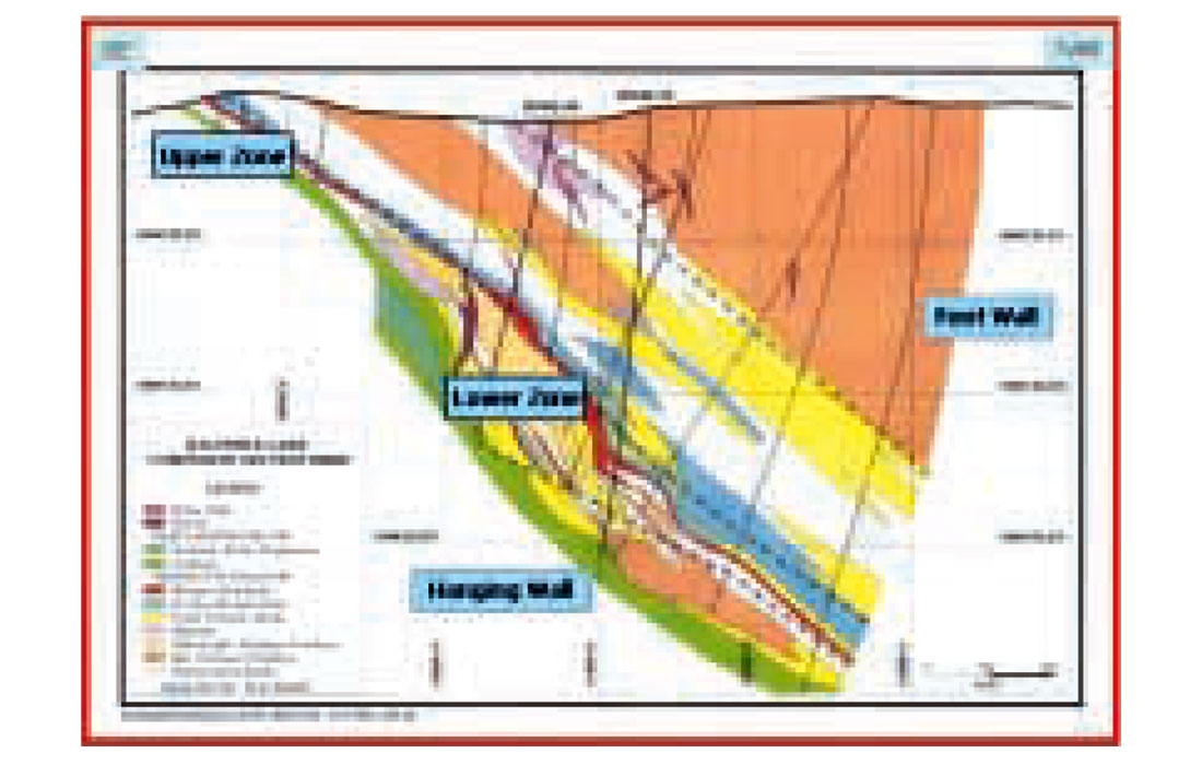
Hosted within the mineralized stratigraphy are two sulphide buildups. The smaller Upper Halfmile zone, containing approximately 1 MT, is exposed at the surface while the larger Lower Halfmile lens contains 6.1 MT of 9.7% Zn, 3.34% Pb, 0.1% Cu and 43 g/t Ag. The lower zone can reach 45 m in thickness and ranges between 400 and 800 m in depth. Both have been carefully mapped and delineated by drilling, making them ideal template targets.
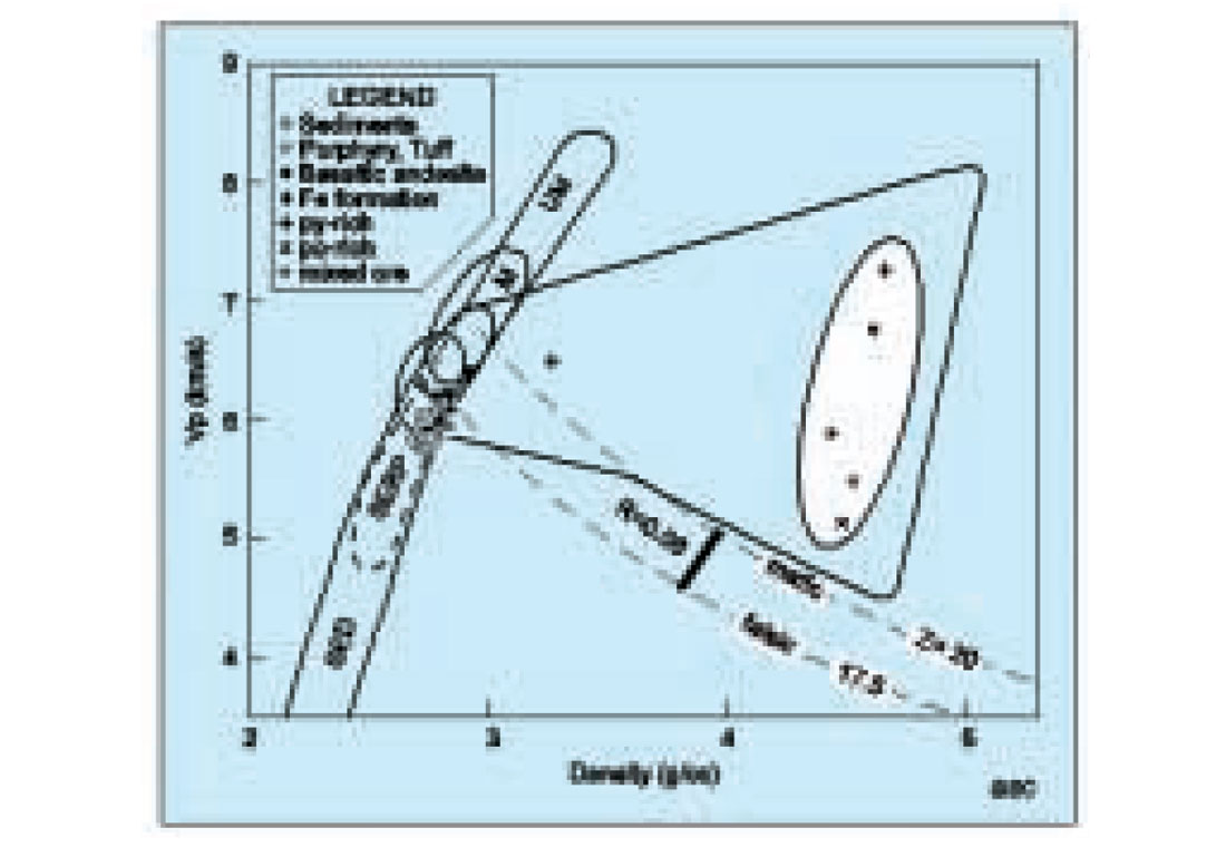
Rock properties conducted on several representative cores covering the range of host lithologies, as well as the sulphide mineralization, can be seen in Figure 2 (Salisbury et al., 1997). Overall, the hosting lithologies tend to cluster (about 6.0 km/s and 2.75 g/cm3) and follow the established Nafe-Drake curve for common silicate crustal rocks. The sulphide mineralization plots at generally higher impedance values and display a wide range of velocities (5.1 – 7.3 km/s) due to varying proportions of pyrrohtite and pyrite. This increasing iron content, while producing an increasingly favourable impedance separation with the host rocks, implies a deceasing amount of economic base metals. Also shown are lines of constant impedance (Z) for typical felsic rocks (17.5) and mafic rocks (20). This crossplot, in combination with selected borehole logs when available, is critical information for establishing which combination of potential rock contacts might provide sufficient impedance contrast to produce a measurable response. The Halfmile Lake prospect was considered by Noranda to be an excellent candidate area to conduct seismic investigations to clearly demonstrate the technical and cost-effective value of seismic data as a deep search technique. The area met a number of desirable criteria, both from the standpoint of ongoing research and its exploration potential. These included:
- Good physical rock properties with the hosting lithologies being essentially acoustically transparent,
- Typical near surface conditions that would be encountered in the camp if seismic methods were ever to be employed as an exploration tool,
- A well delineated existing sulphide orebody that could be used as a template for modelling and proof of technique,
- Structural complexity, typical of the camp,
- Sulphide hosting stratigraphy that was open at depth, and
- A business need to finally establish the ground’s economic potential after nearly half a century.
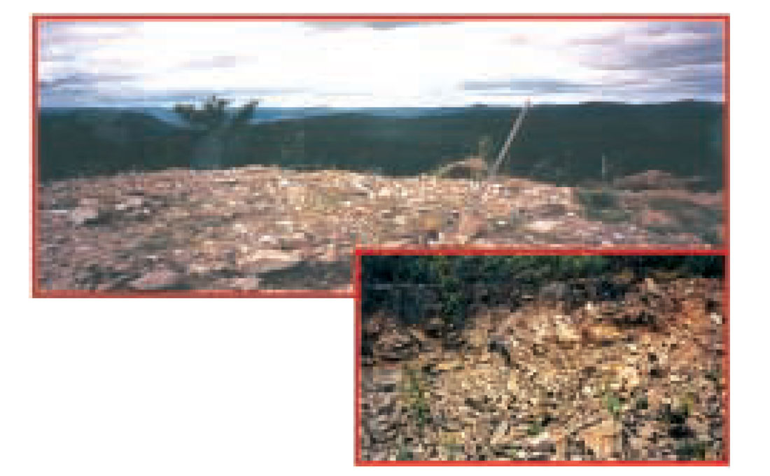
Memorial University of Newfoundland had undertaken an early template seismic data acquisition program at the site in 1993. Even though rock property and modelling at the time had suggested the mineralization would be detected, the 2D survey was unable to image either of the deposits. The low S/N nature of the data was attributed to be primarily the result of recording with an analogue recorder and a less than ideal source and geophone configuration. Even though the results of this survey proved to be less than had been hoped for, it was still believed that the sulphides would be detectable if an adequate S/N dataset could be acquired in the field. As a consequence, in 1995, Noranda returned again to the site and resurveyed the deposit using state-of-the-art field equipment and processing techniques. This time the data did achieve the minimum S/N requirements and proved conclusively that direct detection of massive sulphides was possible in this area (Salisbury et al., 1997). A follow-up 2D line was acquired the next year in an attempt to establish additional drill targets along the new profile as well as to determine the optimum field parameters that would be necessary for any future 3D survey. Parameters tested included such things as charge depth, charge size, charge type, geophone natural frequency and, most importantly, geophone coupling. Figure 3 shows the near surface in this area to have high topographic relief and is generally covered with a layer of moss and tangled roots, although exposed rock and scree slopes are not uncommon. Additionally, the underlying regolith is typically fractured and broken. In combination these two factors produced interesting challenges for geophone coupling and signal penetration. Acquisition programs always required very careful planning and execution as any parameter testing was necessarily conducted in combination with the exploration program itself.
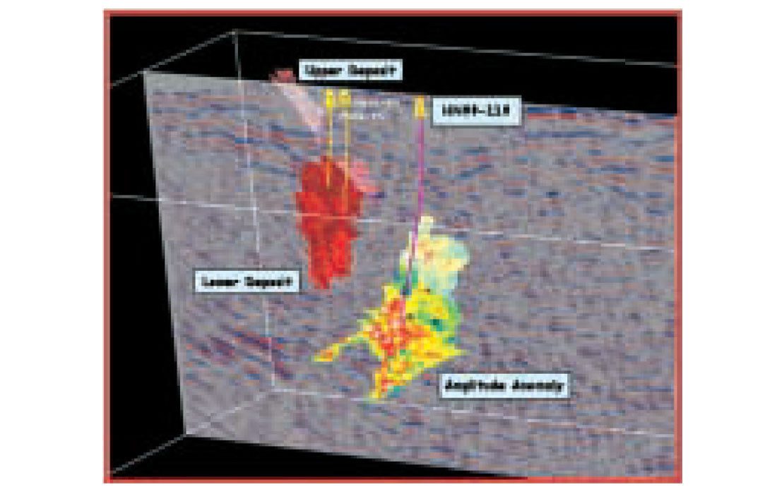
The 1996 profile did identify some new and exciting lead anomalies; however, as a consequence of the very complex structural history of the mining camp, it was very conceivable that the anomalies were originating from some distant out-of-the-plane of the section. To accurately spatially locate and estimate the aerial size of these lead anomalies, as well as any others that were not as yet detected, an 18 km2 3D survey was acquired in the fall of 1998. Significant acoustic impedance anomalies were imaged. One was down-dip (~1000 m) along the trend of the sulphide hosting stratigraphy. The other was significantly larger and at a depth of ~1600 m. The geometry of the impedance anomalies could never have been determined from 2D data alone. Both anomalies were drill tested. The deeper was produced by a broad structural/deformation zone of significant velocity anisotropy within a massive zone of quartz porphyry. Hole HN99-119, targeted on the other amplitude anomaly, intersected ~50 meters of sub-economic massive sulphides containing one 4.5 m zone of ore grade mineralization (10.61% Zn, 1.41% Pb, 0.22% Cu and 14.45 g/t Ag). Figure 4 shows a 3D GoCad view of the interpreted impedance anomaly colour coded by amplitude, a semi-transparent section from the seismic data volume, the Upper and Lower Halfmile Lake sulphide lenses as well as the HN99-119 discovery borehole.
Adding Value
Historically, a discovery at this depth would have required blind pattern drilling to determine accurately the specifics of the target size. This would typically take many months to complete and some of the holes would miss the mineralized zone in order to determine its extent. With the 3D seismic data volume in hand it was hoped that more than just targeting the first borehole would be possible. To show added value, it was important to provide management with a timely, first order estimate of the size and volume of the mineralized zone. A pattern-drilling program in this area, at these depths, could easily cost $100K - $150K per hole. Almost half the cost of the 3D seismic program could be spent on poorly positioned holes to determine the extent of the mineralization and not useful in any way for screening the rest of the stratigraphy covered by the seismic program.
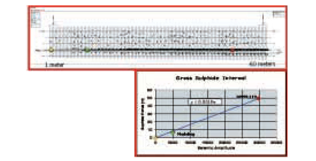
As a consequence of the diamond drilling technique, a continuous rock core is recovered. This provided an accurate thickness for the zone of interest as well as details concerning the mineralogy/density relationship. Armed with this knowledge, as well as the rock property core/log data already in hand, a 2D synthetic wedge model was constructed. Reviewing the seismic data provided an estimate of the background noise amplitude level, which was then added to the synthetic model. After a light spatial smoothing was applied to the target amplitude anomaly, all the information needed to calibrate the synthetic model was available. A crossplot of amplitude versus thickness provided the first order calibration curve by using the HN99-119 data and the estimated background noise and thickness detectability limit of the model wavelet (Kallweit et al., 1982). The wedge model and calibration curve are shown in Figure 5. Using this linear relationship, all the spatially smoothed seismic amplitudes included in the interpreted anomaly were converted to thickness and a first approximation volume calculated. By determining a representative density from the average mineralogy available in the drill core, a final tonnage for the sulphide lens was determined. The estimated tonnage was in the 20 – 25 MT range, which was sufficient to warrant an aggressive delineation program. The spatial location, aerial extent and estimated size derived from the seismic data were all critically important criteria for management to develop the best drilling strategy and scheduling.
This type of modelling was only meant to provide a first order volume estimate. It ignored the effects on amplitude of changing mineralogy, changes in noise, the shape of the sulphide surface, etc., and assumed that the amplitude was driven primarily by thickness when below tuning.
The evaluation drilling program consisted of 9 holes, all targeted by seismic data, and was able to completely evaluate the anomaly for its economic significance in a matter of a few months. The drilling results can be seen in Table 1 and show the mineralization to be sub-economic at this depth. This mineralization had remained undetected throughout almost 50 years of exploration and drilling. The 3D seismic data not only detected the sulphide impedance anomaly at depths beyond 1000 meters but also added additional value by allowing a first order estimate of the anomaly’s size and tonnage, as well as providing exploration screening of the remaining ground covered by the survey.
Conclusions
The technical and exploration success at Halfmile Lake confirms the role that seismic data can play in improving deep-targeting beyond 500 meters. It was the first documented case of yet undiscovered massive sulphides being detected at these great depths. Given the significant cost (~$50,000/km2) to implement a3D survey in these types of crystalline terrains, the seismic method is not intended to be a ubiquitous exploration tool but rather a focussed, collaborative technique in existing mining camps for deep search and area screening. 3D seismic data can provide a very competitive alternative to deep systematic grid drilling provided the necessary ground work of rock properties, modelling and 2D parameter testing warrants its consideration.
Despite the success at Halfmile Lake much work is yet to be done. The challenges to find the investment necessary to continue refining the technology and building its credibility as a viable exploration tool remain. Nevertheless, having been done once with great success, other examples are sure to follow as the need to search for the next new deep discovery persists.

Acknowledgements
The author wishes to acknowledge the many contributions provided by the researchers at the Geological Survey of Canada who laid the groundwork for much of what has been accomplished. Additionally, to the exploration and management staff at Noranda who supported these efforts with their energy and ideas even when success seemed a distant and elusive goal.


Join the Conversation
Interested in starting, or contributing to a conversation about an article or issue of the RECORDER? Join our CSEG LinkedIn Group.
Share This Article